The Inca Trail to Machu Picchu is considered
one of the best treks of the world due the combination of mountains, high cloud
forest and archeological Inca’s sites. The Incas built a highly advanced
network of nearly 40,000 thousand kilometers of trails to connect the distant
corners of their vast empire that stretched from Quito in Ecuador down to
Santiago in Chile and east to Mendoza in Argentina. The named it Capac Ñan and Cusco was the heart of
this great empire.
 |
| Inca Trail Map |
What is known as the Inca Trail is in fact only one of many Inca trails
in the Cusco area. However, this trail has become famous due to its final
destination: Machu Picchu. There is
no better way to arrive to the citadel than on foot at the Sun Gate at dawn, visiting the ruins in the early morning light
before most of the tourists arrive.
They’re many versions of the Inca trail being the 4
days trek also named Classic Inca trail, the
most popular.
There are 500 permits
available each day: approximately 200 are allocated to tourists and 300 to
porters, cooks and guides for that reason it’s highly recommended to book this
trek with at least 4 months of anticipation.
 |
| Starting Point - Km.82 |
The first day of the 4-days Inca Trail starts with a transfer to Km. 82 where all trekkers hike by the shores of the Urubamba River for
around 3 hours up to the archeological site of Llactapata. Then, they continue walking heading for the first camp
in Huayllabamba where they have
dinner and overnight.
Total distance: 12 Km (7,47 miles)
Trekking time: 5 to 6 hours
Highest altitude: 3,000 Mt (9,480 ft.)
Altitude on campsite: 3,000 Mt (9,480 ft.)
The most challenging portion of the trek is the second day with a steep
ascent, followed by 3 hours walking until reaching the first step, Warmiwañusca (Dead Woman), located at
4,200 m.a.s.l. approximately. After
lunch trekkers descend towards Pacaymayu
for dinner and camp.
Total distance: 11 Km (6,84 miles)
Trekking time: 6 to 7 hours
Highest altitude: 4,200 Mt (13,776 ft.)
Altitude on campsite: 3,500 Mt (11,480 ft.)
 |
| Pacaymayu |
 |
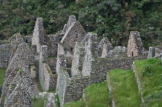
| Wiñayway |
The third day of the trek is a more relaxed, trekking a downhill and mostly flat trail. On route tourists
visit Runcuracay and Sayacmarca archeological sites and then
go on to the Phuyupatamarca ruins. The
last night of camping is at Wiñaywayna
(always young).
Total distance: 16 Km (9,94 miles)
Trekking time: 8 hours
Highest altitude: 3,900 Mt (13,776 ft.)
Altitude on campsite: 2,650 Mt (8,692 ft.)
On the fourth and last day, trekkers start walking for one hour by the forest until reach the Inti Punku (Sun Gate), known like the front door to Machu Picchu, from where everybody have an impressive panoramic view of the Inca citadel. Upon arrival Machu Picchu, trekkers have a guided tour within the citadel visiting the Main Square, the Circular Tower, the Sacred Solar Clock, the Royal Quarters, the temple of the Three Windows and cemeteries.
 |
| Sun Gate |
At the end of the guided
tour they are free to stay longer in the citadel or to take right away the bus
down to Machu Picchu town (also known as
Aguas Calientes) where the booked hotel waits for them with a comfortable
room to rest after the demanding trek.
Best time to go: during the dry season that starts in April and ends around November. The trail is availble anytime except in February when is closed.
Difficulty: more than a walk in the park but less than an alpine climb. If you are in half-decent shape, this 4-days trek will be fine.
The trail goes higher than 4200 meters so you should
spend a bit of time in Cusco to adjust and avoid getting altitude sickness on
the trail.
You can find some tours with this trek in our web page www.peru-tripadvisors.com
Come to Peru and do not miss this unique adventure!
Web form powered by 123ContactForm.com | Report abuse

No comments:
Post a Comment
Please tell us your comments